Corfu Tour and Trail Super-Durable Map
Guidepost price £10.99
In stock
SKU
10-GRE-D01
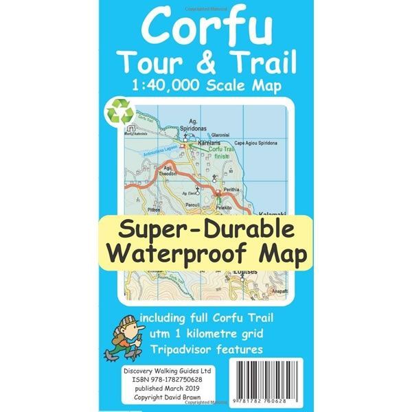
This Corfu Tour and Trail Super-Durable Map covers the island of Corfu at a scale of 1:40,000. It is the most detailed, accurate, toughest, large scale map of the Corfu that you can buy. This double sided map has the northern part of Corfu on 1 side and the southern part on the reverse, with a generous overlap between the 2 sides.
You get the most detailed map of Corfu that is produced including our Tour and Trail level of detail ranging from major roads to secondary roads to minor roads to streets and narrow country roads, plus dirt roads and walking trails.
The map details various walking trails including the full Corfu Trail. All the trails, tracks, lanes and roads that make up the Corfu Trail, including all options, are outlined in green. This makes it easier to identify the Corfu Trail on the map and easier to find it on the ground. Other walking routes are highlighted in grey.
The Corfu Trail was established in 2001. This 220km long distance path runs from Kavos in the south and it finishes at Saint Spiridon Beach in the north. The Corfu Trail leads through a landscape untouched by mass tourism, exploring a variety of Corfu's scenery. This ranges from vast beaches and juniper dunes in the south, through the rolling olive groves in the centre of Corfu, to the karst plateau and rugged gorges in the north. The Corfu Trail is an island paradise ideal for walkers.
Published by Discovery Walking Guides in April 2019 (updated 2nd edition) this Corfu Tour and Trail map is printed on both sides. All the legendary Tour and Trail attention to detail is included such as picnic areas, petrol stations, bar/restaurants and parking areas where you can pull off the road safely.
Scale is:1:40,000
ISBN is: 9781782750628
ISBN is: 9781782750628
We found other products you might like!
-
 Corfu Car Tours and Walks GuidebookGuidepost price £14.99
 -
![Corfu Walking Map [9.4]](https://www.guidepost.uk.com/pub/media/catalog/product/cache/dadd9a99528695eab1f8fe8a8f1ff559/c/o/corfu-walking-map-9-4-2022.jpg) Corfu Walking Map [9.4]Guidepost price £8.50
Corfu Walking Map [9.4]Guidepost price £8.50 -
 Kefalonia Tour & Trail Super-Durable MapGuidepost price £10.99
 -
 Lefkada, Paxos and Antipaxos Tour and Trail MapGuidepost price £10.99